Projects
Machine-learning Analog Retrieval for LINking satellite observations with ocean reanalysis (MARLIN)
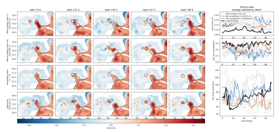
Subseasonal to seasonal (S2S) prediction is crucial for resource management and protection, with ocean features varying significantly on these timescales. The Loop Current (LC) in the Gulf of Mexico exhibits quasi-periodic transitions between retracted, growing, and extended phases that are difficult to predict beyond 2–3 months and nearly impossible to forecast precisely. Accurate LC forecasting is essential because it substantially impacts gulf-wide circulation, hurricane intensification, weather anomalies, offshore oil and gas operations, oil-spill response, fisheries, and ecosystem services. This work uses analog forecasting with SWOT satellite observations and GLORYS ocean reanalysis data to predict LC transitions. The study makes several key innovations: it demonstrates the first skillful LC prediction using analog forecasting methods with ocean reanalysis, improving upon existing approaches through process-specific distance metrics tailored to LC dynamics. The researchers develop a machine learning approach to determine appropriate distance functions when using sparse observational data to identify analogous reanalysis states. Using these retrieved states as an ensemble of initial conditions, they perform analog forecasting of sea surface height in the Gulf of Mexico. Forecast accuracy is evaluated using the Modified Hausdorff Distance to compare LC contour discrepancies and root mean squared error and anomaly correlation coefficient to assess overall spatial SSH differences. This hybrid approach combining observations, reanalysis, and machine learning aims to improve S2S prediction skill for the Loop Current, with implications for operational forecasting and resource management across multiple sectors dependent on Gulf of Mexico conditions.
Neural Ocean Imaging for SWOT, Yielding Smoothed Altimetry through Learned Mapping of Ocean Noise (NOISY SALMON)
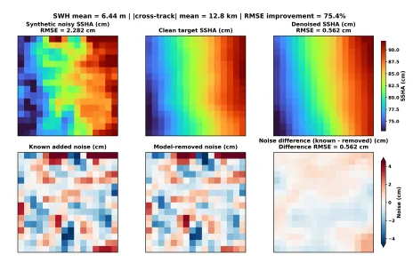
The SWOT satellite, launched in December 2022, captures submesoscale ocean structures (1–30 km) previously undetectable by conventional altimetry, but weak sea surface height signals can be contaminated by high wave conditions, making noise removal critical. Existing denoising methods target approximately 2 km scales using objective mapping and spatial-temporal smoothing, while machine learning approaches typically train on regional ocean simulations as noise-free proxies. For instance, a U-Net model trained on a North Atlantic simulation was applied globally and integrated into DUACS/AVISO Level-3 products, outperforming conventional methods. However, these simulations omit small-scale processes, rely on bulk parameterizations, and underrepresent the energetic, intermittent structures SWOT observes. Consequently, models trained on simulations risk misclassifying genuine ocean variability as noise and removing scientifically meaningful signals like eddies, fronts, filaments, and internal waves. This project develops an observation-driven denoising framework trained directly on SWOT measurements rather than simulations. By learning noise and ocean variability statistics from mission data itself, the approach preserves dynamically important fine-scale features at sub-2 km resolution. The method constructs clean reference tiles from low-wave-height, artifact-free SWOT scenes, generates spatially varying synthetic noise across various sea states and positions, and combines them into noisy-reference pairs. These pairs train a denoiser conditioned on noisy sea surface height anomaly, significant wave height, and cross-track distance, enabling more effective noise suppression while maintaining authentic ocean signals.
Ocean Representation learning for a Coupled Atmosphere (ORCA)
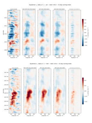
Westerly wind bursts over the western equatorial Pacific Ocean are largely considered the trigger for El Niño-Southern Oscillation progression. SST and SSH each provide insights into the ocean state, but SST alone is typically used to estimate wind stress anomalies. This project aims to incorporate equatorial and sub-tropic SSTA, SSHA, and wind stress anomaly fields from ECCO into machine learning models with differing architectures to ask (1) if machine learning models can reliably forecast wind stress anomalies, and (2) whether SSHA fields contain extractable information about forcing from westerly wind bursts. We train a fine-tuned version of the Earthformer transformer model can forecast wind stress up to 30 days in advance, that achieves an average RMSE of 0.034 Nm−2 at the 30 day lead time. An input ablation test shows very slight increases in the model skill in the equatorial region during an El Niño event when SSHA is used as an input, however the bulk of predictive skill stems from historical wind stress data.
One run instead of twenty: a deep-learning ensemble-mean emulator for eddy-permitting ECCO
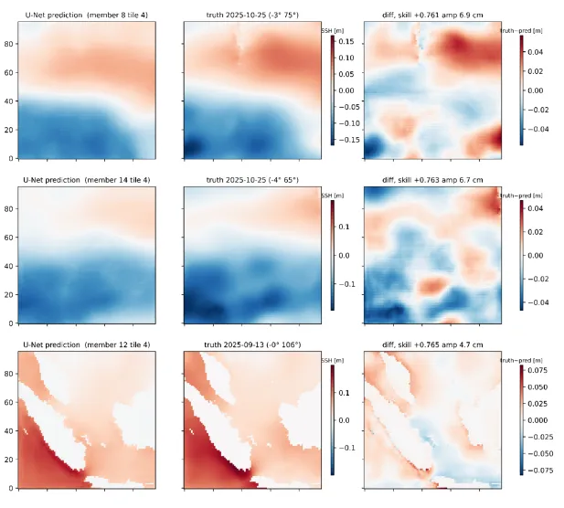
Eddy-resolving ocean simulations entangle the atmospherically forced large-scale circulation with chaotic, intrinsic mesoscale variability. The standard way to isolate the forced signal is a perturbed-initial-condition ensemble whose mean averages the chaos away — but at 1/24°–1/48° resolution, a 20-member ensemble costs 20× the compute of a single run. If the ensemble-averaging operation can be learned, future studies could run one member and recover the correct large-scale signal at a fraction of the cost. In our study, we use Residual Unet, Unet with different training methods gives similar performance. For regions with energetic forcing signals even along with energetic eddy activities, machine learning gives a promising result for getting the ensemble mean without running large-member ensemble runs. The skill of the algorithm could be improved in the future by increasing the number of inputs, for example by providing inputs with temporally finer resolution, or by adding other dynamic variables such as SST and wind stress.
PIXel Cloud-Identifying phase Errors (PIXC-IE)
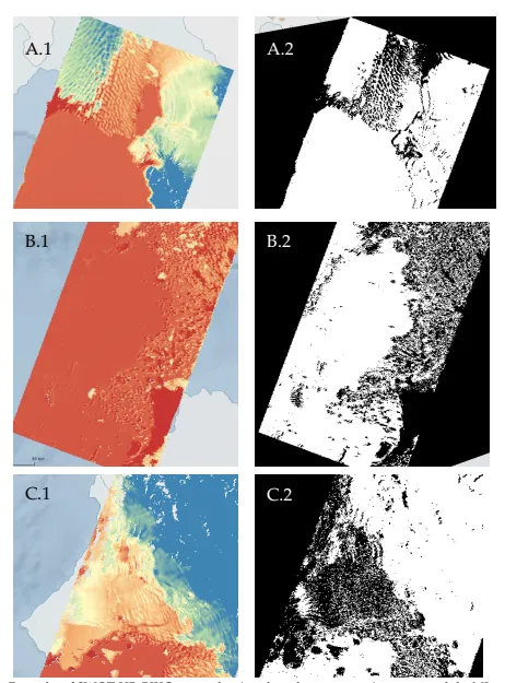
Satellite radar altimetry has monitored polar regions since the 1980s, with each new instrument advancing polar science. NASA's SWOT mission provides unprecedented high-resolution observations of sea ice, coastal regions, and ice-ocean interactions across the Arctic and Antarctic. The High Rate (HR) product offers enhanced spatial and temporal resolution over regions of interest, primarily Greenland and Antarctica, targeting rapidly changing glaciers and coastal areas. However, the processing algorithm and data products require refinement. A significant error in HR data involves incorrect phase in coastal scenes, causing substantial cross-track and along-track height errors in certain pixels. This arises from the instrument's two antennas producing interferograms where multiple points can generate identical range and phase returns. Phase unwrapping corrects these errors by adjusting pixel phase to resolve location and height. The current algorithm references digital elevation models (DEMs) as phase unwrapping guides, but in rapidly evolving regions like coastal West Antarctica, outdated DEMs provide inaccurate reference information, introducing errors in corrected pixels and reducing HR data confidence. Additionally, the current approach assumes erroneous pixels are already identified and grouped as "phase unwrapping regions" for manual adjustment, but where DEMs provide poor references, many problematic pixels remain unidentified, requiring users to manually identify, group, and adjust them. This project investigates machine learning's applicability for automatically identifying pixels requiring phase adjustment. Thwaites Glacier serves as the case study, exhibiting repeated phase unwrapping errors—some consistent, others intermittent—providing diverse training scenarios for developing robust ML models.
SWOT Lead Detection in the Southern Ocean (SLED)
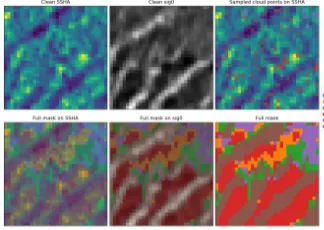
Sea ice leads are narrow cracks in Antarctic sea ice that facilitate air-sea exchange in the Southern Ocean and reveal underlying ocean physics. The SWOT satellite mission offers unprecedented 2D polar ocean coverage, allowing leads to be identified as linear regions with distinctive low sea surface height anomaly and high backscatter signatures, though automated lead detection remains challenging. While ICESat-2 has been used to validate SWOT observations in previous studies, results show varying agreement between the two datasets. The core problem is that SWOT and ICESat-2 operate at different resolutions, measure different physical properties, and have different noise characteristics, making it difficult to extract the complex relationships between SSHA, backscatter, viewing angle, and other variables. This project addresses these limitations by using machine learning to learn non-linear relationships between variables across the two datasets. The researchers also apply self-supervised learning to identify patterns within SWOT data itself. By leveraging machine learning rather than traditional rule-based methods, the approach aims to overcome current constraints and improve lead detection accuracy, ultimately providing better quantification of air-sea exchange in the polar oceans and deeper understanding of sea ice physics.
WAVe and geostrophic Extraction with Supervised learning (WAVES)
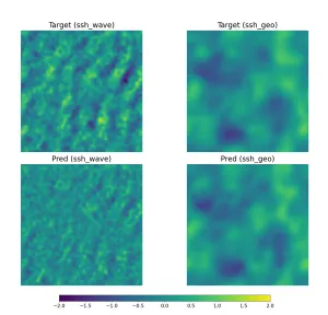
Ocean dynamics fundamentally consist of two types of motion: geostrophic (balanced) flows that evolve slowly through potential vorticity changes, and internal gravity waves that oscillate between the Coriolis and buoyancy frequencies. Energy enters the system through buoyancy forcing, which excites near-geostrophic motions, while wind and tidal forcing excite waves. Through nonlinear interactions, energy cascades to both larger and smaller scales—geostrophic energy cascades upward and dissipates through bottom friction, while wave energy cascades downward where it dissipates or drives ocean mixing. Understanding energy partitioning between these motions is crucial for ocean science. Traditionally, separation relies on temporal frequency differences observed through long-term moored instruments, but SWOT satellite data provides unprecedented spatial resolution of sea surface height with only a 21-day repeat cycle outside the wave frequency band, requiring separation from single temporal snapshots. This work trains machine learning models on semi-realistic ocean simulations where wave-geostrophic separation is known to perform this separation from individual SWOT snapshots. Comparing architectures, the Residual U-Net (R² = 0.5384) outperforms the Fourier Neural Operator (R² = 0.4761), particularly at middle wavenumbers where complex features with strong wave components exist. The inverted FNO performs poorly overall due to weight distribution imbalances. Validation shows the model reconstructs strong wave features accurately but struggles with smaller-scale details, approaching noise levels as features diminish, indicating inherent limitations when separating these motions from spatial snapshots alone.
Waves to Surface Flow
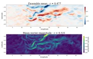
In the open ocean, variability in significant wave height (Hs) at scales smaller than 200 km is strongly influenced by interactions with surface currents (Ardhuin et al., 2017). Recent work by Wang et al. (2025) introduced a simplified forward operator, the U2H map, which predicts current-induced anomalies in Hs given a surface current field and an omnidirectional wave spectrum. However, the inverse problem (recovering the underlying current field from observed wave properties) is highly nonlinear and cannot be directly obtained by simply reversing this operator due to rank-deficiency (Wang et al., 2025). Here, we propose a data-driven approach to learn the inverse problem: a mapping from observed wave properties to the most probable underlying surface currents that could provide a new pathway for estimating surface currents that complements the geostrophic currents routinely derived from conventional satellite altimetry.